
Pleasure Craft Navigation 
Grimsby Small Craft Guidance
Click here
Harbour Authority Byelaws
To download our current set of Harbour Authority byelaws, click here.
General Guidance to Navigation
Associated British Ports (ABP) is the Competent Harbour Authority for the Rivers Humber, Ouse and Trent from the Spurn Light Float, in the approaches to the Humber, to the road bridge known as Stone Bridge at Gainsborough on the River Trent and the railway bridge at Skelton on the River Ouse.
VHF/RADAR
Traffic is monitored on radar and by VHF by Vessel Traffic Services (VTS) Humber from its station on Spurn Point.
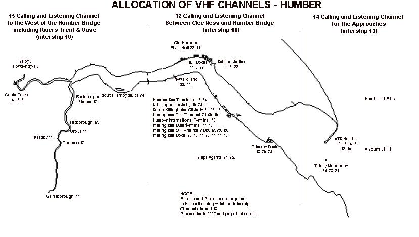
VHF Channel 14 is the main operational working Channel for the Humber Approaches through to the meridian of longitude passing through the No.4A Clee Ness Light Float.
VHF Channel 12 is the main operational channel for the Middle Humber upriver of the meridian of longitude which passes through the No. 4A Clee Ness Light Float to the Humber Bridge.
VHF Channel 15 is the main operational channel for the Upper Humber upriver of the Humber Bridge and includes those areas of the River Ouse and River
Pleasure craft are advised to keep a listening watch on the appropriate VHF channel.
VTS Humber issues 2-hourly weather and navigational broadcasts at 3 minutes past each odd hour.
There is no Harbour Service Patrol, but the RNLI has a lifeboat on permanent standby in the Spurn Bight and the pilotage service operates high-speed pilot launches. In addition, safety rigid inflatables (RIBS) are operated by Humber Rescue and the Coastguard, based at the Humber Bridge and Hull, respectively.
VLSs
Very large ships (VLSs) trade regularly into the Humber. Many of the vessels are restricted in their ability to manoeuvre by their draught and unable to deviate from their course. Yachts and motor launches should give these vessels a wide berth and abide by Rules 9 and 18 of the International Regulations for Preventing Collisions at Sea (1972).
NAVIGATION
Yachts, where possible, should avoid manoeuvring close to jetties and entrances to docks as large vessels, navigating at slow speed, are unable to take avoiding action when berthing/unberthing or entering/leaving enclosed docks. Sufficient water exists for small craft outside the main channel for most states of the tide.
TIDAL RATES
There are many areas in the estuary where the tide runs extremely fast. Craft are, therefore, advised to keep well clear of floating marks, as collision with a float or buoy may result in serious damage.
It is an offence to moor to any navigational mark (Merchant Shipping Act 1894). Water-skiing or aquaplaning, para-kiting or any similar airborne or waterborne activities are regulated by The Humber Navigation Byelaws 1990, Byelaw 36 to which you should refer.
ANCHORING
Safe anchoring can be found in the Spurn Bight, where a yacht buoy is available for mooring purposes. Care must be taken so as not to interfere with pilot- launch operations.
Anchoring is not permitted in a fairway, except in an emergency (The Humber Navigation Byelaws 1990, Byelaw 29). Anchoring is also possible close to the north bank near Hawkins Point. This is the only area on the Lower Humber where any protection can be gained from north-westerly winds.
Safe anchorage can be found close inshore between North Killingholme and Skitter Haven when strong winds are blowing from a direction between west and south-west. Brickyard Chimney provides a useful landmark. The area close inshore at Paull offers shelter from winds from a northerly direction.
HAVENS
There are several small creeks and inlets in the estuary, which may be entered by small craft, although some approaches are difficult to negotiate. They can, however, offer some relief to small craft in an emergency. In general, local knowledge is needed to enter them.
WEATHER CONDITIONS
Care should be taken in navigating the estuary when the wind is against tide. A short choppy sea can rise quickly and prove dangerous to small craft. This is particularly marked in areas of deep water, for example, off Immingham or the areas in the vicinity of the Humber Bridge known locally as "Hessle Whelps" and "Barton Bulldogs".
EMERGENCIES
For small craft emergencies above the Humber Bridge, the ABP Notice to Mariners No. SH.32 applies. This Notice states that "Owners/Skippers of leisure/recreational craft operating on the Humber, west of the Humber Bridge or on the lower reaches of the Rivers Trent and Ouse, are to alert the Maritime and Coastguard Agency on VHF Channel 16 or VTS Humber on VHF Channel 12 or 16 immediately on finding themselves in distress."
In the event of a serious incident involving larger vessels, a special Humber Serious Marine Emergency Plan may be implemented by VTS Humber.
SHOALS
There are many shoal areas throughout the Humber Estuary which can cause a grounding danger for the unwary mariner. It is advisable for pleasure craft to have up-to-date charts, particularly when navigating above Hull. Channels in the Hessle Sand area, as well as those on the Upper Humber, Trent and Ouse can be subject to rapid changes, necessitating regular surveys by ABP's Hydrographic Section. Should your vessel go aground, you are required to notify VTS Humber who will, in turn, inform the Coastguard.
HUMBER APPROACHES
Guidance Notes
The tidal currents in the approaches to the Humber are strong, both on the ebb and the flood. Marked changes to the direction of current flow will be experienced relative to the position of the craft in the estuary or its approaches. The traffic separation scheme takes up the majority of the navigable water in the Humber approaches, therefore, all vessels navigating in the scheme will be affected by the strong currents. Small craft should be aware that vessels can carry a large amount of set and, therefore, the direction indicated by the vessel’s bow is not necessarily an indication of the course the vessel is making, i.e., course made good.
The approaches to the Humber are very busy, with some 40,000 shipping movements per year. Many vessels board and land pilots in the vicinity of the Spurn Light Float which requires the vessel to slow down, alter course to provide a lee (shelter) for safe embarkation or disembarkation of the pilot and thus the vessel will become somewhat limited in its ability to manoeuvre. Sailing craft are therefore recommended to use their engines when navigating in the traffic separation scheme or when crossing the scheme. Attention is drawn to Rule 10 of the Collision Regulations. On entering the approaches, small craft are advised to contact VTS Humber on VHF channel 14, informing them of their position and intentions, thus allowing VTS Humber to monitor their passage through the approaches.
RECOMMENDED ROUTES

Inward from the North
Heading South towards the Spurn Light Float from a Latitude of 53° 35'N, will ensure that craft will pass clear of the Outer Binks. On approaching the Spurn Light Float either join the Traffic Separation Scheme or alter course to make good 245° (T), passing North of the Spurn Light Float and heading for the No.3 Chequer Light Buoy. At the No.3 Light Buoy join the scheme or enter the precautionary zone, heading in a Southerly direction until clear of the scheme before turning to a Westerly direction to pass South of the No.2B Light Buoy; 5 cables South of the Tetney Monobuoy; close South of the No.2C Light Buoy; close West of the No.4 Light Buoy and then to proceed towards the No.4A Cleeness Light Float making a safe entry into the river.
Outward to the North
Small craft may depart using the traffic separation scheme, leaving the scheme using the cautionary zone adjacent to the No 3 Chequer Light Buoy or continuing to join the main cautionary zone past the Spurn Light Float before tuning to the north. A safer route, clear of the larger vessels, would be to reverse the inward recommended track, suggested above.
Inward from the South
Small craft not wishing to use the traffic separation scheme can approach the Humber by passing seaward of the Donna Nook Firing Range, commencing north of the DZ No. 3 Light Buoy, making good a course of 298°T to a position south of the No. 3 Chequer Light Buoy cautionary zone, before altering course to a westerly direction, following the route recommended for small craft from the north at this juncture.
Outward to the South
Small craft, if not wishing to use the traffic separation scheme, can use the reverse of the inward from the south recommended route.
HYDROGRAPHIC AND NAVIGATIONAL NOTES
For Northern approach
The Outer Binks is an area of high sand waves, which experience very rough broken seas, especially with wind against tide.
The Inner Binks, situated to the east and north of Spurn Point, extending out to sea about 2.5 miles has areas which dry out at low water. This area, like the Outer Binks, experiences very rough broken seas. This area should be avoided.
A confused sea with waves of between one and two metres is often experienced, especially during an ebb tide, up to half-a-mile south of Spurn Point head.
For Southern approach
The Lincolnshire coast is mainly featureless and flat and therefore not a good radar target.
A bombing and firing range is situated at Donna Nook. When being used, a listening watch on VHF Channel 16 is kept by the military. The range is marked by the DZ buoys.
There is a dangerous area of sand banks extending from Donna Nook to Haile Sand flat. The drying sands of Haile Sand Flat extend for some three miles north-east of Somercotes Haven and have depths of less than 2 metres extending for a further mile to seaward.
RIVERS TRENT AND OUSE
Many of the guidelines for navigating the lower reaches of the Trent and Ouse are common to both. The rivers are busy commercial waterways with sea-going and barge traffic beyond Goole on the Ouse and beyond Keadby on the Trent.
It is essential that small craft do not impede the passage of the larger vessels, and whenever possible, passing should occur on the straight stretches (reaches).
The wash created by these large vessels is a potential hazard for small craft which should avoid being caught "beam on" to the waves created. Shoals, which can have controlling depths of between 0.5 metres below chart datum, regularly occur and occasionally drying shoals appear.
When rounding the bends "bights", the deepest water is usually found on the outside, but care must be taken not to navigate too close to the extensive stone wall bank protection which covers at about half-tide and can be situated some distance into the river from the green shore.
Jetties and wharves are marked by means of 2 fixed lights vertically displayed, red on the port bank and green on the starboard bank (when navigating from seaward).
SH.32 UPPER HUMBER TRENT AND OUSE
Procedures for leisure/recreational craft in distress primarily west of the Humber Bridge and in the lower reaches of the Rivers Trent and Ouse.
LOWER TRENT NAVIGATION
VHF Channel 15 is used on the Trent and all the Trent wharves use Channel 17. VHF Channel 74 is used by British Waterways.
The Trent is entered by passing the Apex Light on the starboard side, running close to the training wall until just short of the South Trent Beacon and then picking up the Cliff End lights in line in order to pass to the east of the Island Sand, which dries at low water and can be dangerous to small craft, which, if aground on the sand over the low-water period, are likely, due to the strength of the flood tide, to lay over before becoming fully afloat.
(ABP bi-monthly chart "Barton Haven to Burton Stather")
There are a number of shoal areas on the Lower Trent, notably adjacent to Island Sand, Mere Dyke (downstream of Flixborough), Keadby (Keadby Bar), Derrythorpe and the Ewsters (downstream of Owston Ferry). Generally, depths of about 1 metre below chart datum exist over these shoal areas but these can sometimes be reduced to as little as 0.4 metres.
Tide boards (some illuminated) are established at various sites along the river and give the level above chart datum at that place.
As on the Ouse, lighted beacons (red lights on the port side, green lights on the starboard side) assist navigation from downstream of Burton Stather to Keadby.
(ABP annual chart "River Trent, Burton Stather to Keadby")
During spring tides the Aegir, or tidal bore - which can be dangerous for small craft - begins to form on the first of the flood tides and attains its peak between Owston Ferry and Gainsborough about 1 hour before the time of High Water at Hull. It is more pronounced during equinoctial spring tides but is influenced greatly in both its height and velocity by the volume of fresh water present in the Trent.
The Environment Agency can provide additional information about the Aegir.
Small craft may be affected by the flow of drainage water being pumped into the Trent upstream of Keadby Lock and also from the River Idle at West Stockwith. A flashing yellow light is shown while pumping is taking place. In addition, cooling water for the Keadby Power Station is extracted and returned to the Trent, downstream of Keadby Lock.
BRIDGES
The navigation arches of the following bridges are all marked by means of 2 fixed red lights vertically displayed on the east (port) side and 2 fixed green lights vertically displayed on the west (starboard) side. In addition, a fixed yellow light marks the centre of the arch.
Keadby Bridge
Air draught at the level of "Mean High Water Spring Tides" is 5.1 metres. An illuminated air-draught board is situated on the eastern bank close downstream of the navigational arch.
M180 motorway bridge
Air draught at the level of Mean High Water Spring Tides is 8.1 metres over the centre 30 metres width.
Gainsborough Bridge
Air draught at the level of Mean High Water Spring Tides is 4.7 metres.
LOWER OUSE NAVIGATION
The Ouse is entered by passing the Apex Light on the port side, running close alongside the training wall until abreast of No. 2 Light Beacon and then crossing towards Blacktoft Jetty on the opposite bank. Green leading lights (rear occulting, front flashing), sited on the jetty, assist navigation over this stretch.
Craft entering the Ouse can contact the Port of Goole or Blacktoft Jetty on VHF Channel 14 and can obtain the latest depth information for the various Ouse reaches. This information is also contained in the regular river broadcasts by VTS Humber on Channel 12. Blacktoft Jetty is intended for use by commercial shipping between tides. Pleasure craft are discouraged from mooring alongside except in an emergency. A charge is levied for mooring at this facility.
Lighted beacons (red lights on the port side, green lights on the starboard side) assist navigation between Blacktoft and Goole. The River Don enters the Ouse on the port side immediately before the Port of Goole.
- (ABP annual chart "River Ouse, Apex Lighthouse to Skelton Bridge").